
Peak Forest topographic map
Interactive map
Click on the map to display elevation.
About this map
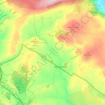
Name: Peak Forest topographic map, elevation, terrain.
Average elevation: 1,227 ft
Minimum elevation: 676 ft
Maximum elevation: 1,818 ft
Other topographic maps
Click on a map to view its topography, its elevation and its terrain.
The Slopes
United Kingdom > England > High Peak
The Slopes, High Peak, Derbyshire, East Midlands, England, United Kingdom
Average elevation: 1,096 ft
Kinder Scout
United Kingdom > England > High Peak
Kinder Scout, High Peak, Derbyshire, East Midlands, England, S33 7ZJ, United Kingdom
Average elevation: 1,827 ft