
Parkland topographic map
Interactive map
Click on the map to display elevation.
About this map
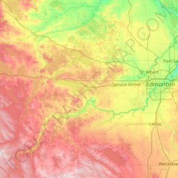
Name: Parkland topographic map, elevation, terrain.
Location: Parkland, Alberta, Canadá (52.86506 -114.99292 54.14506 -113.71292)
Average elevation: 2,513 ft
Minimum elevation: 1,978 ft
Maximum elevation: 3,451 ft
Other topographic maps
Click on a map to view its topography, its elevation and its terrain.
Río Athabasca
Río Athabasca, Municipal District of Lesser Slave River, Alberta, T9S 1H4, Canadá
Average elevation: 2,283 ft