
Jones topographic map
Click on the map to display elevation.
Jones
Jones is primarily an agricultural municipality best suited for the intensive production of rice and corn as evidence by its topographic map which shows that 73% of the agricultural area of 16,848 hectares is under 0-3 slope category.
About this map
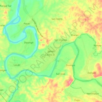
Name: Jones topographic map, elevation, terrain.
Location: Jones, Isabela, Cagayan Valley, Philippines (16.52078 121.66169 16.60078 121.74169)
Average elevation: 325 ft
Minimum elevation: 194 ft
Maximum elevation: 492 ft
Other topographic maps
Click on a map to view its topography, its elevation and its terrain.