
Make a donation
Gear up for your next adventure:
As an Amazon Associate, this site earns from qualifying purchases at no extra cost to you.
Indian Springs topographic map
Click on the map to display elevation.
Make a donation
Gear up for your next adventure:
As an Amazon Associate, this site earns from qualifying purchases at no extra cost to you.
Indian Springs
One year later, Indian Springs was reactivated as Indian Springs Air Force Base by the new United States Air Force, with a new role as a new weapons systems and aircraft research and testing. Among these missions were support for nuclear arms testing at the Nevada Proving Grounds, high-altitude balloon search and retrieval, new gunnery and rocketry systems, and testing of experimental aircraft. For a period of the 1950s and 1960s Indian Springs AFB housed some of the most advanced aircraft and air weapons systems in the world.
Make a donation
Gear up for your next adventure:
As an Amazon Associate, this site earns from qualifying purchases at no extra cost to you.
About this map
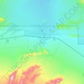
Name: Indian Springs topographic map, elevation, terrain.
Location: Indian Springs, Clark County, Nevada, United States (36.54362 -115.80646 36.59616 -115.63600)
Average elevation: 3,537 ft
Minimum elevation: 3,051 ft
Maximum elevation: 5,223 ft
Clark County trails, hiking, mountain biking, running and outdoor activities
Make a donation
Gear up for your next adventure:
As an Amazon Associate, this site earns from qualifying purchases at no extra cost to you.