
Make a donation
Gear up for your next adventure:
As an Amazon Associate, this site earns from qualifying purchases at no extra cost to you.
Castres topographic map
Click on the map to display elevation.
Make a donation
Gear up for your next adventure:
As an Amazon Associate, this site earns from qualifying purchases at no extra cost to you.
Castres
Castres is located at an altitude of 172 metres (564 feet) above sea level. It is located 45 km (28 mi) south-southeast of Albi, the préfecture (capital) of Tarn, and 79 km (49 mi) east of Toulouse, the capital of Occitania. Castres is intersected from north to south by the rivers Agout and Durenque.
Make a donation
Gear up for your next adventure:
As an Amazon Associate, this site earns from qualifying purchases at no extra cost to you.
About this map
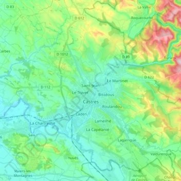
Name: Castres topographic map, elevation, terrain.
Location: Castres, Tarn, Occitania, Metropolitan France, 81100, France (43.55594 2.15632 43.67033 2.33343)
Average elevation: 755 ft
Minimum elevation: 502 ft
Maximum elevation: 1,529 ft
Make a donation
Gear up for your next adventure:
As an Amazon Associate, this site earns from qualifying purchases at no extra cost to you.
Other topographic maps
Click on a map to view its topography, its elevation and its terrain.
Make a donation
Gear up for your next adventure:
As an Amazon Associate, this site earns from qualifying purchases at no extra cost to you.