
Latacunga topographic map
Interactive map
Click on the map to display elevation.
About this map
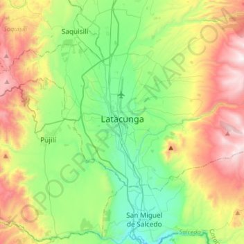
Name: Latacunga topographic map, elevation, terrain.
Location: Latacunga, Cotopaxi, Ecuador (-1.00867 -78.66718 -0.86744 -78.40152)
Average elevation: 10,217 ft
Minimum elevation: 8,428 ft
Maximum elevation: 13,504 ft
Other topographic maps
Click on a map to view its topography, its elevation and its terrain.
San Fransisco
Ecuador > Cotopaxi > Latacunga > Latacunga
San Fransisco, Eloy Alfaro, Latacunga, Cotopaxi, 050105, Ecuador
Average elevation: 9,472 ft
San Francisco
Ecuador > Cotopaxi > Latacunga > Toacaso > San Francisco
San Francisco, Toacaso, Latacunga, Cotopaxi, Ecuador
Average elevation: 10,787 ft