Geolocate

Latacunga topographic map

Click on the map to display elevation.

About this map

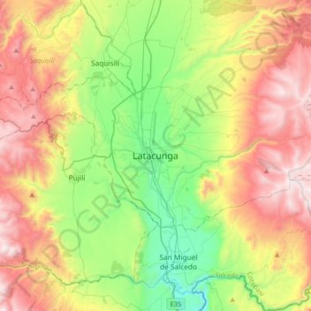
Name: Latacunga topographic map, elevation, terrain.

Location: Latacunga, Cotopaxi, 0501, Ecuador (-1.09403 -78.77458 -0.77403 -78.45458)

Average elevation: 10,541 ft

Minimum elevation: 8,287 ft

Maximum elevation: 13,665 ft

Gear up for your next adventure:

🏔️Mountain Trail Maps - High‑detail maps for popular peaks
🗃️Trail First Aid Kit - Essential kit for outdoor injuries and emergencies
🔥Plasma Lighters - Windproof lighters that work in any weather condition
🪶Compact Camp Shovel - Folding shovel for campsite tasks
📶Vehicle Signal Boosters - Improve reception in rural areas while driving to trailheads

As an Amazon Associate, this site earns from qualifying purchases at no extra cost to you.