Geolocate

Knysna topographic map

Click on the map to display elevation.

About this map

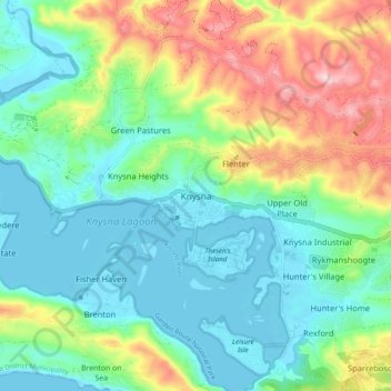
Name: Knysna topographic map, elevation, terrain.

Location: Knysna, George, Western Cape, 6570, South Africa (-34.07573 23.00849 -33.99573 23.08849)

Average elevation: 312 ft

Minimum elevation: -10 ft

Maximum elevation: 1,020 ft

Other topographic maps

Click on a map to view its topography, its elevation and its terrain.

Oudtshoorn

South Africa > Western Cape > George

Average elevation: 1,158 ft

Touwsranten

South Africa > Western Cape > George

Average elevation: 663 ft

Garden Route Dam

South Africa > Western Cape > George

Average elevation: 656 ft

Oudtshoorn

South Africa > Western Cape > George

Average elevation: 1,158 ft

Friemersheim

South Africa > Western Cape > George

Average elevation: 860 ft

Oudtshoorn

South Africa > Western Cape > George

Average elevation: 1,158 ft

Danabaai

South Africa > Western Cape > George

Average elevation: 358 ft

Gear up for your next adventure:

🥇GPS Hiking Watch - Multi‑sport GPS watch with navigation and trail tracking
🧼Biodegradable Camping Soap - Eco‑friendly soap for outdoor hygiene
GPS Sports Watch - GPS watch for running, hiking and training
🎒Trail Energy Bars - High‑calorie bars for hiking energy
🎒Outdoor Daypacks - Lightweight backpacks designed for carrying maps and essential gear

As an Amazon Associate, this site earns from qualifying purchases at no extra cost to you.