
Abuja topographic map
Click on the map to display elevation.
Abuja
The elevation is 360 metres (1,180 ft).
About this map
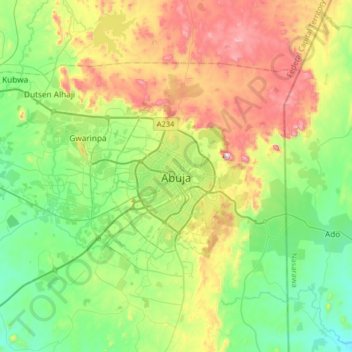
Name: Abuja topographic map, elevation, terrain.
Average elevation: 1,667 ft
Minimum elevation: 955 ft
Maximum elevation: 3,041 ft
Other topographic maps
Click on a map to view its topography, its elevation and its terrain.
Gwarinpa
Nigeria > Federal Capital Territory > Municipal Area Council > Gwarinpa
Average elevation: 1,545 ft
Central Business District
Nigeria > Federal Capital Territory > Municipal Area Council
Average elevation: 1,621 ft
Maitama
Nigeria > Federal Capital Territory > Municipal Area Council > Abuja
Average elevation: 1,680 ft
Katampe
Nigeria > Federal Capital Territory > Municipal Area Council > Abuja
Average elevation: 1,640 ft
Central Business District
Nigeria > Federal Capital Territory > Municipal Area Council
Average elevation: 1,621 ft
Central Business District
Nigeria > Federal Capital Territory > Municipal Area Council
Average elevation: 1,621 ft
Gwarinpa
Nigeria > Federal Capital Territory > Municipal Area Council > Gwarinpa
Average elevation: 1,545 ft