
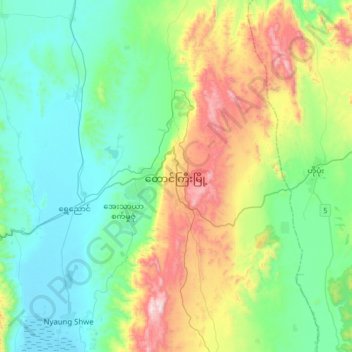
Taunggyi topographic map
Interactive map
Click on the map to display elevation.
About this map
Name: Taunggyi topographic map, elevation, terrain.
Average elevation: 3,770 ft
Minimum elevation: 2,900 ft
Maximum elevation: 6,145 ft
Taunggyi (Burmese: တောင်ကြီးမြို့; MLCTS: taung kri: mrui. [tàʊɰ̃dʑí mjo̰]; Shan: ဝဵင်းတူၼ်ႈတီး [weŋ˥ ton˧˧˨ ti˥]; Pa'O: ဝေင်ꩻတောင်းကီꩻ) is the capital and largest city of Shan State, Myanmar (Burma) and lies on the Thazi-Kyaingtong road at an elevation of 4,712 feet (1,436 m), just north of Shwenyaung and Inle Lake within the Myelat region. Taunggyi is the fifth largest city of Myanmar, and has an estimated population of 380,665 as of 2014. The city is famous for its hot air balloon festival held annually on the full moon day of Tazaungmon.
Other topographic maps
Click on a map to view its topography, its elevation and its terrain.
Doi Lang
Myanmar > Shan State > Mong Hsat District
Doi Lang, Mong Ton Township, Mong Hsat District, East Shan State, Shan State, Wa State Southern region, Myanmar
Average elevation: 6,079 ft
Moe Meik
Moe Meik, Mong Mit Township, Mong Mit District, North Shan State, Shan State, Myanmar
Average elevation: 646 ft
Lashio Township
Lashio Township, Lashio District, North Shan State, Shan State, 06301, Myanmar
Average elevation: 2,976 ft
Hpau Jung Pa
Myanmar > Shan State > Mu Se District > Muse Township
Hpau Jung Pa, Muse Township, Mu Se District, North Shan State, Shan State, Myanmar
Average elevation: 3,373 ft
Par Pee
Myanmar > Shan State > Mong Khet Township > Par Pee
Par Pee, Mong Khet Township, Kengtung District, East Shan State, Shan State, Wa State Northern Region, Myanmar
Average elevation: 4,580 ft
Kalaw Township
Myanmar > Shan State > Kalaw Township
Kalaw Township, Taunggyi District, South Shan State, Shan State, Myanmar
Average elevation: 3,898 ft
Tarlay
Myanmar > Shan State > Tachileik District > Tachileik Township > Tarlay
Tarlay, Tachileik Township, Tachileik District, East Shan State, Shan State, Myanmar
Average elevation: 1,608 ft
Loilem
Myanmar > Shan State > Loilem
Loilem, Loilen District, South Shan State, Shan State, Myanmar
Average elevation: 4,147 ft
Ho Mun
Myanmar > Shan State > Kengtung District > Mong Yang Township > Ho Mun
Ho Mun, Mong Yang Township, Kengtung District, East Shan State, Shan State, Wa State Northern Region, Myanmar
Average elevation: 4,685 ft