
Tarbert topographic map
Interactive map
Click on the map to display elevation.
About this map
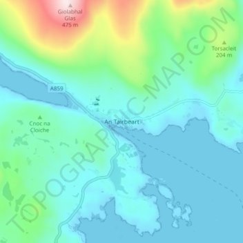
Name: Tarbert topographic map, elevation, terrain.
Location: Tarbert, Western Isles, Scotland, HS3 3DB, United Kingdom (57.87802 -6.81916 57.91802 -6.77916)
Average elevation: 285 ft
Minimum elevation: -3 ft
Maximum elevation: 1,549 ft
Other topographic maps
Click on a map to view its topography, its elevation and its terrain.
Tigharry
United Kingdom > Scotland > Western Isles
Tigharry, Western Isles, Scotland, HS6 5DE, United Kingdom
Average elevation: 36 ft
Reef
United Kingdom > Scotland > Western Isles
Reef, Western Isles, Scotland, HS2 9HU, United Kingdom
Average elevation: 59 ft
Scarista
United Kingdom > Scotland > Western Isles
Scarista, Western Isles, Scotland, HS3 3HX, United Kingdom
Average elevation: 197 ft
Àird
United Kingdom > Scotland > Western Isles
Àird, Western Isles, Scotland, United Kingdom, Benbecula
Average elevation: 16 ft
Vatersay
United Kingdom > Scotland > Western Isles > Vatersay
Vatersay, Western Isles, Scotland, United Kingdom
Average elevation: 62 ft
Tong
United Kingdom > Scotland > Western Isles
Tong, Western Isles, Scotland, HS2 0HJ, United Kingdom
Average elevation: 49 ft
St Kilda
United Kingdom > Scotland > Western Isles
St Kilda, Western Isles, Scotland, United Kingdom
Average elevation: 36 ft