
Reef topographic map
Click on the map to display elevation.
About this map
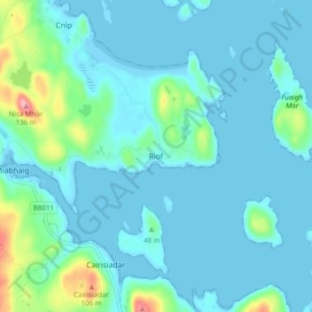
Name: Reef topographic map, elevation, terrain.
Location: Reef, Western Isles, Scotland, HS2 9HU, United Kingdom (58.18474 -6.94460 58.22474 -6.90460)
Average elevation: 59 ft
Minimum elevation: -13 ft
Maximum elevation: 410 ft
Other topographic maps
Click on a map to view its topography, its elevation and its terrain.
Àird
United Kingdom > Scotland > Western Isles
There is a dense cluster of lochs across almost the entire island, and almost all of the island is below 20 metres (70 feet) in elevation.
Average elevation: 16 ft