
Make a donation
Gear up for your next adventure:
As an Amazon Associate, this site earns from qualifying purchases at no extra cost to you.
Riosucio topographic map
Click on the map to display elevation.
Make a donation
Gear up for your next adventure:
As an Amazon Associate, this site earns from qualifying purchases at no extra cost to you.
Riosucio
The municipality is located in the west of the department. It is bounded by the municipality of Supía to the east, the municipality of Filadelfia to the south-east, the department of Risaralda to the south and west, and the department of Antioquia to the north. The total area of the municipality is 429.1 km2. The town of Riosucio lies at an altitude of 1783 meters above sea level, 91 km west of the departmental capital Manizales.
Make a donation
Gear up for your next adventure:
As an Amazon Associate, this site earns from qualifying purchases at no extra cost to you.
About this map
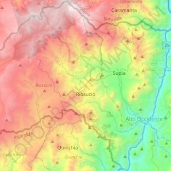
Name: Riosucio topographic map, elevation, terrain.
Average elevation: 6,060 ft
Minimum elevation: 2,096 ft
Maximum elevation: 10,656 ft
Make a donation
Gear up for your next adventure:
As an Amazon Associate, this site earns from qualifying purchases at no extra cost to you.
Other topographic maps
Click on a map to view its topography, its elevation and its terrain.
Manizales
Manizales is the capital city of one of the smallest Colombian departments. The city is described as having an "abrupt topography", and lies on the Colombian Central Mountain Range (part of the longest continental mountain range, the Andes), with a great deal of ridgelines and steep slopes, which, combined…
Average elevation: 6,594 ft
Make a donation
Gear up for your next adventure:
As an Amazon Associate, this site earns from qualifying purchases at no extra cost to you.