Geolocate

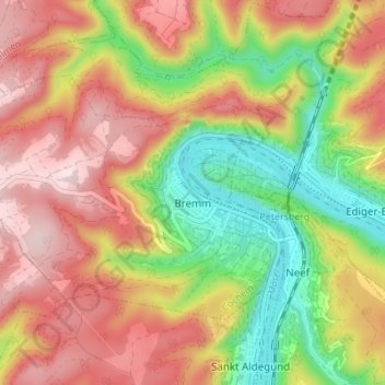
Bremm topographic map

Click on the map to display elevation.

Bremm

The municipality lies at a bow in the river Moselle between Trier and Koblenz, among the sloped vineyards of the Calmont, which with an elevation of 380 m above sea level and a slope of roughly 65° is Europe’s steepest vineyard location. This stretches along the Moselle from Ediger-Eller to Bremm, and is part of the Mosel wine region.

Wikipedia (CC-BY-SA 3.0)

About this map

Name: Bremm topographic map, elevation, terrain.

Location: Bremm, Cochem, Landkreis Cochem-Zell, Rhineland-Palatinate, Germany (50.08509 7.06760 50.11395 7.13606)

Average elevation: 846 ft

Minimum elevation: 253 ft

Maximum elevation: 1,385 ft

Gear up for your next adventure:

🥾Hiking Shoes - Durable and comfortable shoes for trail hiking
⛑️Personal Locator Beacon - Safety beacon for emergencies
🧯Portable Fire Pit - Compact fire pit for camping spots
🗃️Trail First Aid Kit - Essential kit for outdoor injuries and emergencies
📱Solar Portable Charger - Solar power bank for charging devices off‑grid

As an Amazon Associate, this site earns from qualifying purchases at no extra cost to you.