
Pacucha topographic map
Interactive map
Click on the map to display elevation.
About this map
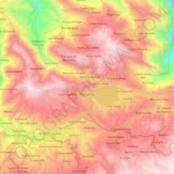
Name: Pacucha topographic map, elevation, terrain.
Location: Pacucha, Provincia de Andahuaylas, Apurímac, Perú (-13.65856 -73.42466 -13.54191 -73.20710)
Average elevation: 10,741 ft
Minimum elevation: 5,876 ft
Maximum elevation: 13,793 ft
Other topographic maps
Click on a map to view its topography, its elevation and its terrain.
Laguna Pacucha
Laguna Pacucha, AP-101, Ccaccsa, Pacucha, Provincia de Andahuaylas, Apurímac, Perú
Average elevation: 10,358 ft