
Vermilion-on-the-Lake topographic map
Interactive map
Click on the map to display elevation.
About this map
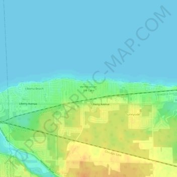
Name: Vermilion-on-the-Lake topographic map, elevation, terrain.
Average elevation: 597 ft
Minimum elevation: 564 ft
Maximum elevation: 666 ft
Other topographic maps
Click on a map to view its topography, its elevation and its terrain.
Vermilion River
United States > Ohio > Lorain County > Vermilion
Vermilion River, Vermilion, Brownhelm Township, Lorain County, Ohio, United States
Average elevation: 656 ft