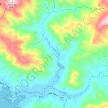
La Coulée (fleuve) topographic map
Interactive map
Click on the map to display elevation.
About this map
Name: La Coulée (fleuve) topographic map, elevation, terrain.
Average elevation: 741 ft
Minimum elevation: -16 ft
Maximum elevation: 2,618 ft

Click on the map to display elevation.
Name: La Coulée (fleuve) topographic map, elevation, terrain.
Average elevation: 741 ft
Minimum elevation: -16 ft
Maximum elevation: 2,618 ft