
La Blaquière topographic map
Interactive map
Click on the map to display elevation.
About this map
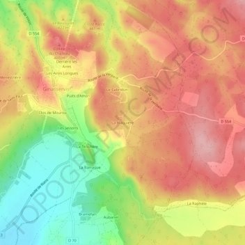
Name: La Blaquière topographic map, elevation, terrain.
Average elevation: 1,345 ft
Minimum elevation: 1,047 ft
Maximum elevation: 1,558 ft
Other topographic maps
Click on a map to view its topography, its elevation and its terrain.
Les Aires Longues
France > Provence-Alpes-Côte d'Azur > Var > Ginasservis
Les Aires Longues, Ginasservis, Brignoles, Var, Provence-Alpes-Côte d'Azur, France métropolitaine, 83560, France
Average elevation: 1,348 ft