
Gangotri National Park topographic map
Interactive map
Click on the map to display elevation.
About this map
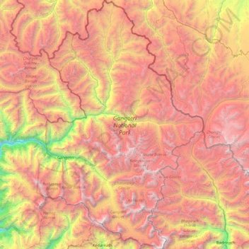
Name: Gangotri National Park topographic map, elevation, terrain.
Average elevation: 16,430 ft
Minimum elevation: 8,192 ft
Maximum elevation: 23,409 ft
The park harbors Western Himalayan subalpine conifer forests at lower elevations and Western Himalayan alpine shrub and meadows at higher elevations. Vegetation consist of chirpine deodar, fir, spruce, oak and rhododendrons.
Other topographic maps
Click on a map to view its topography, its elevation and its terrain.
Didsari
India > Uttarakhand > Bhatwari
Didsari, Bhatwari, Uttarkashi district, Uttarakhand, India
Average elevation: 5,909 ft
Dayara
India > Uttarakhand > Bhatwari
Dayara, Bhatwari, Uttarkashi district, Uttarakhand, India
Average elevation: 11,184 ft
Uttarkashi
India > Uttarakhand > Bhatwari
Uttarkashi, Bhatwari, Uttarkashi district, Uttarakhand, 249193, India
Average elevation: 5,312 ft
Shivling
India > Uttarakhand > Bhatwari
Shivling, Bhatwari, Uttarkashi district, Uttarakhand, India
Average elevation: 17,848 ft
Gangotri
India > Uttarakhand > Bhatwari
Gangotri, Bhatwari, Uttarkashi District, Uttarakhand, India
Average elevation: 13,579 ft
Barsu
India > Uttarakhand > Bhatwari > Barsu
Barsu, Bhatwari, Uttarkashi, Uttarakhand, India
Average elevation: 7,618 ft
Raithal
India > Uttarakhand > Bhatwari > Raithal
Raithal, Bhatwari, Uttarkashi, Uttarakhand, India
Average elevation: 6,962 ft
Bhaironghati
India > Uttarakhand > Bhatwari > Lanka > Bhaironghati
Bhaironghati, Lanka, Bhatwari, Uttarkashi, Uttarakhand, India
Average elevation: 10,587 ft
Bhatwari
India > Uttarakhand > Bhatwari
Bhatwari, Uttarkashi district, Uttarakhand, India
Average elevation: 15,000 ft
Gangotri Glacier
India > Uttarakhand > Bhatwari
Gangotri Glacier, Bhatwari, Uttarkashi, Uttarakhand, India
Average elevation: 17,254 ft