
Kanan topographic map
Interactive map
Click on the map to display elevation.
About this map
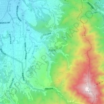
Name: Kanan topographic map, elevation, terrain.
Location: Kanan, Minamikawachi County, Osaka Prefecture, Japan (34.44633 135.61244 34.51488 135.68481)
Average elevation: 974 ft
Minimum elevation: 121 ft
Maximum elevation: 3,123 ft
Other topographic maps
Click on a map to view its topography, its elevation and its terrain.
Mt. Yamato-Katsuragi
Japan > Osaka Prefecture > Minamikawachi County > Chihaya-akasaka
Mt. Yamato-Katsuragi, Chihaya-akasaka, Minamikawachi County, Osaka Prefecture, 585-0041, Japan
Average elevation: 2,142 ft