
Ceres topographic map
Interactive map
Click on the map to display elevation.
About this map
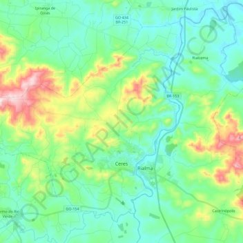
Name: Ceres topographic map, elevation, terrain.
Average elevation: 2,087 ft
Minimum elevation: 1,677 ft
Maximum elevation: 3,356 ft
Other topographic maps
Click on a map to view its topography, its elevation and its terrain.
Evereste
Brésil > Goiás > Niquelândia
Evereste, Niquelândia, Região Geográfica Imediata de Uruaçu - Niquelândia, Região Geográfica Intermediária de Porangatu-Uruaçu, Goiás, Région Centre-Ouest, Brésil
Average elevation: 2,008 ft
Alto Paraíso de Goiás
Brésil > Goiás > Alto Paraíso de Goiás
Alto Paraíso de Goiás, Microrregião da Chapada dos Veadeiros, Mesorregião Norte Goiano, Goiás, Région Centre-Ouest, 73770000, Brésil
Average elevation: 2,844 ft