Geolocate

Comuna Rural de Aldea Beleiro topographic map

Click on the map to display elevation.

About this map

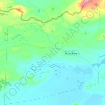
Name: Comuna Rural de Aldea Beleiro topographic map, elevation, terrain.

Location: Comuna Rural de Aldea Beleiro, Departamento Río Senguer, Chubut Province, 9037, Argentina (-45.60197 -71.61472 -45.50181 -71.48520)

Average elevation: 2,398 ft

Minimum elevation: 2,156 ft

Maximum elevation: 3,556 ft

Other topographic maps

Click on a map to view its topography, its elevation and its terrain.

Nahuel Pan

Argentina > Chubut Province > Municipio de Esquel

Average elevation: 2,644 ft

Cerro Chenque

Argentina > Chubut Province

Average elevation: 4,262 ft

Rawson

Argentina > Chubut Province

Average elevation: 30 ft

Trelew

Argentina > Chubut Province

Average elevation: 233 ft

Tecka River

Argentina > Chubut Province

Average elevation: 2,956 ft

Gear up for your next adventure:

🚪Portable Camp Chair - Foldable chair for comfort at camp
🪶Multi‑Purpose Knife - Useful blade for camp and trail
🌡️Portable Weather Meter - Track weather conditions on the trail
🥾Men's Hiking Boots - Durable, waterproof footwear for rugged terrain and steep inclines
📦Gear Storage Bags - Organize and protect outdoor equipment

As an Amazon Associate, this site earns from qualifying purchases at no extra cost to you.