
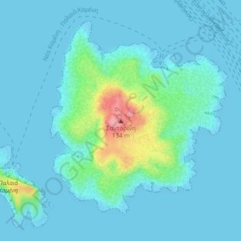
Σαντορίνη topographic map
Interactive map
Click on the map to display elevation.
About this map
Name: Σαντορίνη topographic map, elevation, terrain.
Average elevation: 56 ft
Minimum elevation: 0 ft
Maximum elevation: 397 ft
Other topographic maps
Click on a map to view its topography, its elevation and its terrain.
Stegna
Griechenland > Ägäis > Regionalbezirk Rhodos > Archangelos
Stegna, Archangelos, Δήμος Ρόδου, Regionalbezirk Rhodos, Region Südliche Ägäis, Ägäis, 851 02, Griechenland
Average elevation: 266 ft
Lesbos
Griechenland > Ägäis > Mytilini
Lesbos, Mytilini, Δήμος Λέσβου, Region Nördliche Ägäis, Ägäis, 81100, Griechenland
Average elevation: 243 ft
Nisyros
Nisyros, Δήμος Νισύρου, Regionalbezirk Kos, Region Südliche Ägäis, Ägäis, 85303, Griechenland
Average elevation: 413 ft
Andros
Andros, Gemeinde Andros, Regionalbezirk Andros, Region Südliche Ägäis, Ägäis, Griechenland
Average elevation: 272 ft
Nea Kameni
Nea Kameni, Δήμος Θήρας, Regionalbezirk Thira, Region Südliche Ägäis, Ägäis, Griechenland
Average elevation: 52 ft
Region Südliche Ägäis
Region Südliche Ägäis, Ägäis, Griechenland
Average elevation: 276 ft
Δήμος Κω
Δήμος Κω, Regionalbezirk Kos, Region Südliche Ägäis, Ägäis, Griechenland
Average elevation: 82 ft