
Casey Key topographic map
Interactive map
Click on the map to display elevation.
About this map
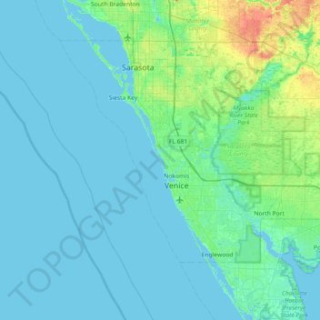
Name: Casey Key topographic map, elevation, terrain.
Location: Casey Key, Sarasota County, Florida, 34274, USA (26.83005 -82.80065 27.47005 -82.16065)
Average elevation: 16 ft
Minimum elevation: -7 ft
Maximum elevation: 115 ft
Other topographic maps
Click on a map to view its topography, its elevation and its terrain.
The Villages
USA > Florida > The Villages
The Villages, Lake County, Florida, USA
Average elevation: 89 ft
Yeet Pond
USA > Florida > Palm Coast
Yeet Pond, South Coopers Hawk Way, Palm Coast, Flagler County, Florida, USA
Average elevation: 23 ft
Miami Beach
USA > Florida > Miami Beach
Miami Beach, Miami-Dade County, Florida, USA
Average elevation: 10 ft
Dry Tortugas National Park
Dry Tortugas National Park, Monroe County, Florida, USA
Average elevation: 0 ft
St. Augustine
USA > Florida > St. Augustine
St. Augustine, St. Johns County, Florida, 32084, USA
Average elevation: 16 ft
Deerfield Beach
USA > Florida > Deerfield Beach
Deerfield Beach, Broward County, Florida, USA
Average elevation: 16 ft
Altamonte Springs
USA > Florida > Altamonte Springs
Altamonte Springs, Seminole County, Florida, USA
Average elevation: 85 ft
Dawson Island
USA > Florida > Jacksonville
Dawson Island, Jacksonville, Duval County, Florida, USA
Average elevation: 7 ft