
Medelon topographic map
Interactive map
Click on the map to display elevation.
About this map
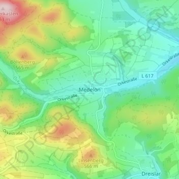
Name: Medelon topographic map, elevation, terrain.
Average elevation: 1,467 ft
Minimum elevation: 1,158 ft
Maximum elevation: 2,139 ft
Other topographic maps
Click on a map to view its topography, its elevation and its terrain.
Deifeld
Duitsland > Noordrijn-Westfalen > Hochsauerlandkreis > Medebach
Deifeld, Medebach, Hochsauerlandkreis, Noordrijn-Westfalen, 59964, Duitsland
Average elevation: 1,850 ft
Titmaringhausen
Duitsland > Noordrijn-Westfalen > Hochsauerlandkreis > Medebach > Titmaringhausen
Titmaringhausen, Medebach, Hochsauerlandkreis, Noordrijn-Westfalen, 34508, Duitsland
Average elevation: 2,031 ft
Küstelberg
Duitsland > Noordrijn-Westfalen > Hochsauerlandkreis > Medebach
Küstelberg, Medebach, Hochsauerlandkreis, Noordrijn-Westfalen, Duitsland
Average elevation: 2,175 ft