
Praslin topographic map
Interactive map
Click on the map to display elevation.
About this map
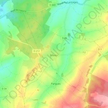
Name: Praslin topographic map, elevation, terrain.
Average elevation: 682 ft
Minimum elevation: 515 ft
Maximum elevation: 899 ft
Other topographic maps
Click on a map to view its topography, its elevation and its terrain.
Le Village
France > Grand Est > Aube > Dolancourt
Le Village, Dolancourt, Bar-sur-Aube, Aube, Grand Est, Metropolitan France, 10200, France
Average elevation: 666 ft
Metz-Robert
Metz-Robert, Troyes, Aube, Grand Est, Metropolitan France, 10210, France
Average elevation: 502 ft
Dolancourt
Dolancourt, Bar-sur-Aube, Aube, Grand Est, Metropolitan France, 10200, France
Average elevation: 646 ft
Maizières-la-Grande-Paroisse
France > Grand Est > Aube > Maizières-la-Grande-Paroisse
Maizières-la-Grande-Paroisse, Nogent-sur-Seine, Aube, Grand Est, Metropolitan France, 10510, France
Average elevation: 262 ft
Grandville
Grandville, Troyes, Aube, Grand Est, Metropolitan France, 10700, France
Average elevation: 420 ft