
Fronhausen topographic map
Interactive map
Click on the map to display elevation.
About this map
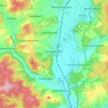
Name: Fronhausen topographic map, elevation, terrain.
Average elevation: 722 ft
Minimum elevation: 525 ft
Maximum elevation: 1,148 ft
Other topographic maps
Click on a map to view its topography, its elevation and its terrain.
Hassenhausen
Deutschland > Hessen > Landkreis Marburg-Biedenkopf > Fronhausen
Hassenhausen, Fronhausen, Landkreis Marburg-Biedenkopf, Hessen, Deutschland
Average elevation: 732 ft