
Make a donation
Gear up for your next adventure:
As an Amazon Associate, this site earns from qualifying purchases at no extra cost to you.
Liberec topographic map
Click on the map to display elevation.
Make a donation
Gear up for your next adventure:
As an Amazon Associate, this site earns from qualifying purchases at no extra cost to you.
About this map
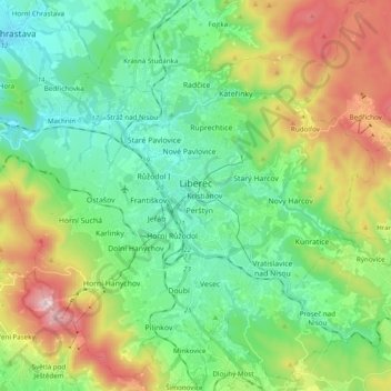
Name: Liberec topographic map, elevation, terrain.
Location: Liberec, okres Liberec, Liberec Region, Northeast, Czechia (50.70798 14.95297 50.82434 15.14688)
Average elevation: 1,673 ft
Minimum elevation: 958 ft
Maximum elevation: 3,268 ft
Make a donation
Gear up for your next adventure:
As an Amazon Associate, this site earns from qualifying purchases at no extra cost to you.
Other topographic maps
Click on a map to view its topography, its elevation and its terrain.
Černá Novina
Czechia > Liberec Region > SO ORP Česká Lípa > Hamr na Jezeře
Average elevation: 1,273 ft
Dlouhá hora
Czechia > Liberec Region > SO ORP Liberec > Chrastava > Andělská Hora u Chrastavy
Average elevation: 1,745 ft
Dlouhá hora
Czechia > Liberec Region > Chrastava > Andělská Hora u Chrastavy
Average elevation: 1,745 ft
Make a donation
Gear up for your next adventure:
As an Amazon Associate, this site earns from qualifying purchases at no extra cost to you.