Geolocate

Raglan topographic map

Click on the map to display elevation.

About this map

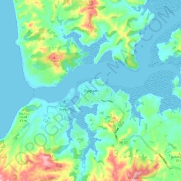
Name: Raglan topographic map, elevation, terrain.

Location: Raglan, Waikato District, Waikato, 3225, New Zealand (-37.83977 174.82825 -37.75977 174.90825)

Average elevation: 135 ft

Minimum elevation: -3 ft

Maximum elevation: 748 ft

Gear up for your next adventure:

💧Water Filtration Bottles - Safely drink from streams and lakes while exploring
🕶️GPS Smartphone Mount - Secure mount for phone navigation
🪶Thermal Camp Blanket - Extra warmth for cold nights
🛡️Insect Repellent - Protection against bugs during outdoor activities
📷Action Cameras - Rugged cameras to document your journeys across rugged terrain

As an Amazon Associate, this site earns from qualifying purchases at no extra cost to you.