
Make a donation
Gear up for your next adventure:
As an Amazon Associate, this site earns from qualifying purchases at no extra cost to you.
Coronel topographic map
Click on the map to display elevation.
Make a donation
Gear up for your next adventure:
As an Amazon Associate, this site earns from qualifying purchases at no extra cost to you.
About this map
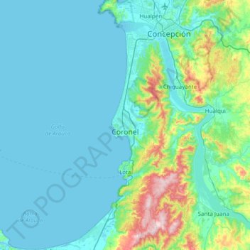
Name: Coronel topographic map, elevation, terrain.
Average elevation: 289 ft
Minimum elevation: -3 ft
Maximum elevation: 2,221 ft
Make a donation
Gear up for your next adventure:
As an Amazon Associate, this site earns from qualifying purchases at no extra cost to you.
Other topographic maps
Click on a map to view its topography, its elevation and its terrain.
Agua de la Gloria
Chile > Biobío Region > Provincia de Concepción > Concepcion > El Pino
Average elevation: 308 ft
Make a donation
Gear up for your next adventure:
As an Amazon Associate, this site earns from qualifying purchases at no extra cost to you.
Casa Poli
Chile > Biobío Region > Provincia de Concepción > Dichato > Camino a Los Cerezos Bajo
Average elevation: 89 ft