
Make a donation
Gear up for your next adventure:
As an Amazon Associate, this site earns from qualifying purchases at no extra cost to you.
Rüdesheim topographic map
Click on the map to display elevation.
Make a donation
Gear up for your next adventure:
As an Amazon Associate, this site earns from qualifying purchases at no extra cost to you.
Rüdesheim
Rüdesheim lies in the transitional zone between Rhenish Hesse and the Hunsrück at the mouth of the Katzenbach, where it empties into the Ellerbach, itself a tributary to the Nahe. Although that river lies a short way outside Rüdesheim, the municipality still styles itself “an der Nahe” (“on the Nahe”) and claims that it lies im Herzen des wunderschönen Nahetals (“in the heart of the wonderfully lovely Nahe valley”). The village is found some 4 km west of the district seat of Bad Kreuznach, with which it has all but grown together into one built-up area. The village sits at an elevation of 135 m above sea level. The municipal area measures 3.47 km².
Make a donation
Gear up for your next adventure:
As an Amazon Associate, this site earns from qualifying purchases at no extra cost to you.
About this map
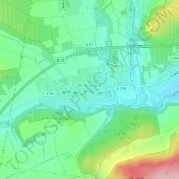
Name: Rüdesheim topographic map, elevation, terrain.
Average elevation: 541 ft
Minimum elevation: 364 ft
Maximum elevation: 984 ft
Make a donation
Gear up for your next adventure:
As an Amazon Associate, this site earns from qualifying purchases at no extra cost to you.