
Ayazağa Mahallesi topographic map
Interactive map
Click on the map to display elevation.
About this map
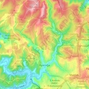
Name: Ayazağa Mahallesi topographic map, elevation, terrain.
Location: Ayazağa Mahallesi, Sarıyer, Istanbul, Marmara Region, Turkey (41.10210 28.95876 41.15206 29.01863)
Average elevation: 305 ft
Minimum elevation: 30 ft
Maximum elevation: 587 ft
Other topographic maps
Click on a map to view its topography, its elevation and its terrain.
İstinye Mahallesi
İstinye Mahallesi, Sarıyer, Istanbul, Marmara Region, Turkey
Average elevation: 151 ft
Reşitpaşa Mahallesi
Reşitpaşa Mahallesi, Sarıyer, Istanbul, Marmara Region, Turkey
Average elevation: 213 ft