
Make a donation
Gear up for your next adventure:
As an Amazon Associate, this site earns from qualifying purchases at no extra cost to you.
Strafford topographic map
Click on the map to display elevation.
Make a donation
Gear up for your next adventure:
As an Amazon Associate, this site earns from qualifying purchases at no extra cost to you.
About this map
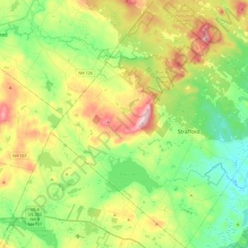
Name: Strafford topographic map, elevation, terrain.
Location: Strafford, Strafford County, New Hampshire, United States (43.20370 -71.24599 43.35532 -71.05471)
Average elevation: 663 ft
Minimum elevation: 226 ft
Maximum elevation: 1,378 ft
Strafford County trails, hiking, mountain biking, running and outdoor activities
Make a donation
Gear up for your next adventure:
As an Amazon Associate, this site earns from qualifying purchases at no extra cost to you.
Other topographic maps
Click on a map to view its topography, its elevation and its terrain.
Milton Three Ponds Dam
United States > New Hampshire > Strafford County > Milton
Average elevation: 525 ft
Make a donation
Gear up for your next adventure:
As an Amazon Associate, this site earns from qualifying purchases at no extra cost to you.