
Thank you for supporting this site ❤️
Make a donation
Make a donation
Gear up for your next adventure:
As an Amazon Associate, this site earns from qualifying purchases at no extra cost to you.
Langenhain topographic map
Click on the map to display elevation.
Thank you for supporting this site ❤️
Make a donation
Make a donation
Gear up for your next adventure:
As an Amazon Associate, this site earns from qualifying purchases at no extra cost to you.
About this map
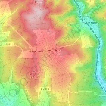
Name: Langenhain topographic map, elevation, terrain.
Location: Langenhain, Hofheim am Taunus, Main-Taunus-Kreis, Hesse, Germany (50.08332 8.35943 50.12501 8.42914)
Average elevation: 906 ft
Minimum elevation: 433 ft
Maximum elevation: 1,325 ft
Thank you for supporting this site ❤️
Make a donation
Make a donation
Gear up for your next adventure:
As an Amazon Associate, this site earns from qualifying purchases at no extra cost to you.