
Canelas topographic map
Interactive map
Click on the map to display elevation.
About this map
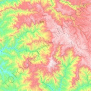
Name: Canelas topographic map, elevation, terrain.
Location: Canelas, Durango, México (24.94762 -106.71079 25.19720 -106.12304)
Average elevation: 5,240 ft
Minimum elevation: 1,224 ft
Maximum elevation: 9,793 ft
Other topographic maps
Click on a map to view its topography, its elevation and its terrain.
Durango
México > Durango > Municipio de Durango
Durango, Municipio de Durango, Durango, México
Average elevation: 6,352 ft
Palestina
México > Durango > Santiago Papasquiaro
Palestina, Santiago Papasquiaro, Durango, México
Average elevation: 6,572 ft
San Pedro Alcantara
México > Durango > San Pedro Alcantara
San Pedro Alcantara, Vicente Guerrero, Durango, México
Average elevation: 6,460 ft