
Sanford Flat topographic map
Interactive map
Click on the map to display elevation.
About this map
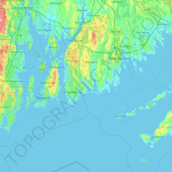
Name: Sanford Flat topographic map, elevation, terrain.
Average elevation: 36 ft
Minimum elevation: -39 ft
Maximum elevation: 449 ft
Other topographic maps
Click on a map to view its topography, its elevation and its terrain.
Brownell Corner
United States > Massachusetts > Bristol County > Westport > Brownell Corner
Brownell Corner, Westport, Bristol County, Massachusetts, 02790, United States
Average elevation: 161 ft