
Cemaes topographic map
Click on the map to display elevation.
About this map
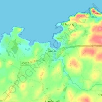
Name: Cemaes topographic map, elevation, terrain.
Location: Cemaes, Isle of Anglesey, Wales, LL67 0EY, United Kingdom (53.39272 -4.47377 53.43272 -4.43377)
Average elevation: 66 ft
Minimum elevation: -3 ft
Maximum elevation: 217 ft
Other topographic maps
Click on a map to view its topography, its elevation and its terrain.
Llanfairpwllgwyngyll
United Kingdom > Wales > Isle of Anglesey > Llanfairpwllgwyngyll
Average elevation: 138 ft