
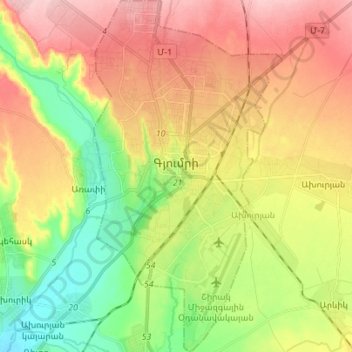
Gyumri topographic map
Interactive map
Click on the map to display elevation.
About this map
Name: Gyumri topographic map, elevation, terrain.
Location: Gyumri, Akhuryan region, Shirak Province, Armenia (40.72834 43.80913 40.83313 43.88367)
Average elevation: 5,036 ft
Minimum elevation: 4,787 ft
Maximum elevation: 5,305 ft
Gyumri is 126 kilometres (78 miles) north of the capital Yerevan at the central part of the Shirak plateau. It has an approximate height of 1,550 metres (5,090 feet) above sea level, the high altitude line being 1,500 metres (4,900 feet). The Akhurian River passes through the western suburbs. The Shirak plateau is surrounded with the Pambak Mountains from the east and Aragats volcanic range from the south. The city of Gyumri is 196 kilometres (122 miles) away from the Black Sea. The surrounding lands near the city are rich in tufa, basalt and clay.
Other topographic maps
Click on a map to view its topography, its elevation and its terrain.
Mount Aragats
Armenia > Shirak Province > Gyumri
Mount Aragats, Gyumri, Shirak Province, Armenia
Average elevation: 11,699 ft
Gyumri
Armenia > Shirak Province > Gyumri
Gyumri, Border Gyumri, Shirak Province, 3104, Armenia
Average elevation: 5,614 ft