
Make a donation
Gear up for your next adventure:
As an Amazon Associate, this site earns from qualifying purchases at no extra cost to you.
Kangbashi District topographic map
Click on the map to display elevation.
Make a donation
Gear up for your next adventure:
As an Amazon Associate, this site earns from qualifying purchases at no extra cost to you.
About this map
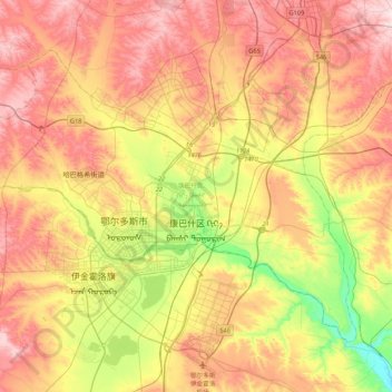
Name: Kangbashi District topographic map, elevation, terrain.
Average elevation: 4,459 ft
Minimum elevation: 3,842 ft
Maximum elevation: 5,026 ft
Make a donation
Gear up for your next adventure:
As an Amazon Associate, this site earns from qualifying purchases at no extra cost to you.
Other topographic maps
Click on a map to view its topography, its elevation and its terrain.
Make a donation
Gear up for your next adventure:
As an Amazon Associate, this site earns from qualifying purchases at no extra cost to you.
Longshengzhuang
China > Inner Mongolia > Fengzhen City > Ulanqab City > Longshengzhuang
Average elevation: 4,567 ft
Make a donation
Gear up for your next adventure:
As an Amazon Associate, this site earns from qualifying purchases at no extra cost to you.
Make a donation
Gear up for your next adventure:
As an Amazon Associate, this site earns from qualifying purchases at no extra cost to you.
Zhengxiangbai Banner
China > Inner Mongolia > Zhengxiangbai Banner > Minggat
Average elevation: 4,491 ft