Geolocate

Waltwilder topographic map

Click on the map to display elevation.

About this map

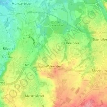
Name: Waltwilder topographic map, elevation, terrain.

Location: Waltwilder, Bilzen, Tongeren, Limburg, Flanders, Belgium (50.84804 5.53243 50.88965 5.56901)

Average elevation: 246 ft

Minimum elevation: 118 ft

Maximum elevation: 413 ft

Gear up for your next adventure:

🧯Portable Fire Pit - Compact fire pit for camping spots
📱Solar Portable Charger - Solar power bank for charging devices off‑grid
🔦LED Headlamp - Bright and durable LED headlamp for night navigation
🪶Camping Sleeping Pad - Comfortable sleeping pad for backpacking
🦶Hiking Gaiters - Keep debris and water out of your boots

As an Amazon Associate, this site earns from qualifying purchases at no extra cost to you.