Geolocate

Konya topographic map

Click on the map to display elevation.

About this map
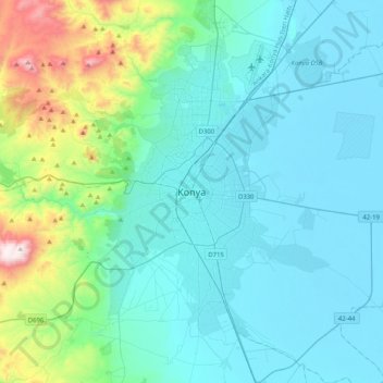
Name: Konya topographic map, elevation, terrain.

Location: Konya, Selçuklu, Konya, Central Anatolia Region, 42040, Turkey (37.71273 32.33244 38.03273 32.65244)

Average elevation: 3,806 ft

Minimum elevation: 3,278 ft

Maximum elevation: 6,732 ft

Other topographic maps

Click on a map to view its topography, its elevation and its terrain.

Sille Mahallesi

Turkey > Selçuklu

Average elevation: 4,157 ft

Aşağıpınarbaşı Mahallesi

Turkey > Selçuklu

Average elevation: 3,369 ft

Gear up for your next adventure:

🧢Outdoor Hiking Hat - Sun protection hat for outdoor explorers
🔭Telescopic Hiking Pole - Adjustable pole for hiking stability
🧦Merino Wool Socks - Moisture-wicking, blister-preventing socks for long treks
🪶Camping Sleeping Pad - Comfortable sleeping pad for backpacking
🛠️Backpacking Tool Kit - Essential toolkit for outdoor repairs

As an Amazon Associate, this site earns from qualifying purchases at no extra cost to you.