
Maria Langegg topographic map
Interactive map
Click on the map to display elevation.
About this map
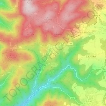
Name: Maria Langegg topographic map, elevation, terrain.
Average elevation: 1,644 ft
Minimum elevation: 820 ft
Maximum elevation: 2,365 ft
Other topographic maps
Click on a map to view its topography, its elevation and its terrain.
Nesselstauden
Österreich > Niederösterreich > Bezirk Krems > Bergern im Dunkelsteinerwald > Maria Langegg
Nesselstauden, Maria Langegg, Bergern im Dunkelsteinerwald, Bezirk Krems, Niederösterreich, 3122, Österreich
Average elevation: 1,696 ft