
Willowbrook topographic map
Click on the map to display elevation.
About this map
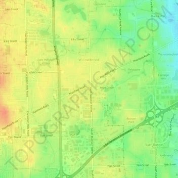
Name: Willowbrook topographic map, elevation, terrain.
Location: Willowbrook, DuPage County, Illinois, United States (41.74269 -87.96430 41.78330 -87.92323)
Average elevation: 719 ft
Minimum elevation: 640 ft
Maximum elevation: 778 ft
DuPage County trails, hiking, mountain biking, running and outdoor activities
Other topographic maps
Click on a map to view its topography, its elevation and its terrain.
Downers Grove
United States > Illinois > DuPage County > Downers Grove > Downers Grove
Average elevation: 745 ft