
Akkulam Tourist Village topographic map
Interactive map
Click on the map to display elevation.
About this map
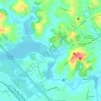
Name: Akkulam Tourist Village topographic map, elevation, terrain.
Average elevation: 62 ft
Minimum elevation: 3 ft
Maximum elevation: 213 ft
Other topographic maps
Click on a map to view its topography, its elevation and its terrain.
Neyyar Dam
India > Kerala > Thiruvananthapuram
Neyyar Dam, Thiruvananthapuram, Kerala, 695001, India
Average elevation: 299 ft
Aakulam park
India > Kerala > Thiruvananthapuram
Aakulam park, Paruthipara, Thiruvananthapuram, Kerala, 695001, India
Average elevation: 121 ft
Aruvikkara Dam
India > Kerala > Thiruvananthapuram
Aruvikkara Dam, Nedumangad, Thiruvananthapuram, Kerala, 695564, India
Average elevation: 210 ft
Mannanthala
India > Kerala > Thiruvananthapuram > Mannanthala
Mannanthala, Thiruvananthapuram, Kerala, 695001, India
Average elevation: 167 ft
Statue
India > Kerala > Thiruvananthapuram
Statue, Mahatma Gandhi Road, Palayam, Thampanoor, Thiruvananthapuram, Kerala, 695001, India
Average elevation: 89 ft