
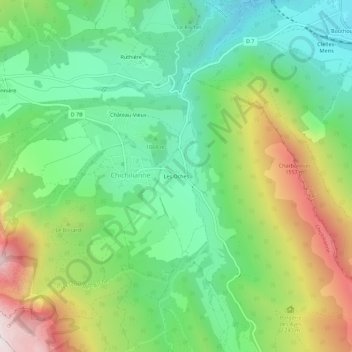
Les Oches topographic map
Interactive map
Click on the map to display elevation.
About this map
Name: Les Oches topographic map, elevation, terrain.
Average elevation: 3,711 ft
Minimum elevation: 2,589 ft
Maximum elevation: 5,725 ft
Other topographic maps
Click on a map to view its topography, its elevation and its terrain.
Donnière
France > Auvergne-Rhône-Alpes > Isère > Chichilianne > Donnière
Donnière, Chichilianne, Grenoble, Isère, Auvergne-Rhône-Alpes, France métropolitaine, 38930, France
Average elevation: 4,160 ft
Charbonnier
France > Auvergne-Rhône-Alpes > Isère > Chichilianne
Charbonnier, Chichilianne, Grenoble, Isère, Auvergne-Rhône-Alpes, France métropolitaine, 38930, France
Average elevation: 3,691 ft
Mont Aiguille
France > Auvergne-Rhône-Alpes > Isère > Chichilianne
Mont Aiguille, Chichilianne, Grenoble, Isère, Auvergne-Rhône-Alpes, France métropolitaine, 38930, France
Average elevation: 4,577 ft
Richardière
France > Auvergne-Rhône-Alpes > Isère > Chichilianne
Richardière, Chichilianne, Grenoble, Isère, Auvergne-Rhône-Alpes, France métropolitaine, 38930, France
Average elevation: 4,278 ft
Ruthière
France > Auvergne-Rhône-Alpes > Isère > Chichilianne
Ruthière, Chichilianne, Grenoble, Isère, Auvergne-Rhône-Alpes, France métropolitaine, 38930, France
Average elevation: 3,714 ft
Prarron
France > Auvergne-Rhône-Alpes > Isère > Chichilianne > Château-Vieux
Prarron, Château-Vieux, Chichilianne, Grenoble, Isère, Auvergne-Rhône-Alpes, France métropolitaine, 38930, France
Average elevation: 3,514 ft