
Ruayer topographic map
Interactive map
Click on the map to display elevation.
About this map
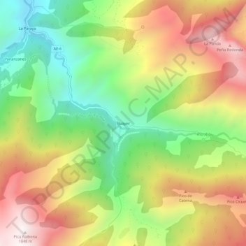
Name: Ruayer topographic map, elevation, terrain.
Location: Ruayer, Aller, Asturies, 33681, Espagne (43.03479 -5.57068 43.07479 -5.53068)
Average elevation: 3,944 ft
Minimum elevation: 2,093 ft
Maximum elevation: 6,037 ft
Other topographic maps
Click on a map to view its topography, its elevation and its terrain.
Felguerúa
Espagne > Asturies > Aller > Morea/Moreda
Felguerúa, Morea/Moreda, Aller, Asturies, 33679, Espagne
Average elevation: 1,759 ft
Morea/Moreda
Morea/Moreda, Aller, Asturies, 33670, Espagne
Average elevation: 2,139 ft