
Cordillera topographic map
Interactive map
Click on the map to display elevation.
About this map
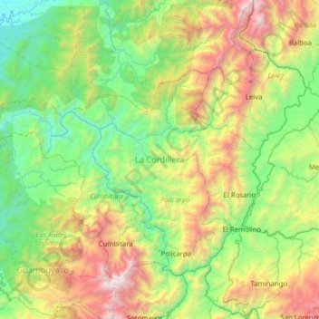
Name: Cordillera topographic map, elevation, terrain.
Location: Cordillera, Nariño, Colombia (1.50060 -77.71813 2.12503 -77.20363)
Average elevation: 3,566 ft
Minimum elevation: 108 ft
Maximum elevation: 11,811 ft
Other topographic maps
Click on a map to view its topography, its elevation and its terrain.
LA BRAVA - R?O GUANA
Colombia > Nariño > Tumaco > Kaunapi
LA BRAVA - R?O GUANA, Kaunapi, Tumaco, Pacífico Sur, Nariño, Colombia
Average elevation: 59 ft
San Fransico (6)
Colombia > Nariño > Contadero > Contadero
San Fransico (6), Contadero, Ex-Providencia de Obando, Nariño, Colombia
Average elevation: 9,199 ft