Geolocate

Burgos topographic map

Click on the map to display elevation.

About this map

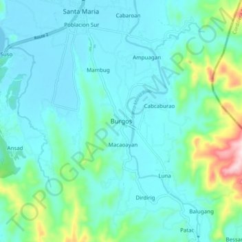
Name: Burgos topographic map, elevation, terrain.

Location: Burgos, Ilocos Sur, Ilocos Region, 2705, Philippines (17.29353 120.45478 17.37353 120.53478)

Average elevation: 203 ft

Minimum elevation: 0 ft

Maximum elevation: 1,194 ft

Other topographic maps

Click on a map to view its topography, its elevation and its terrain.

Bessang Pass

Philippines > Ilocos Sur

Average elevation: 4,518 ft

Gear up for your next adventure:

🧯Emergency Survival Kit - All‑in‑one survival essentials for the backcountry
🔥Fast-Boil Camping Stoves - Efficient cooking systems for quick trail meals
🔦LED Headlamp - Bright and durable LED headlamp for night navigation
🔭Compact Binoculars - HD vision for scouting terrain and identifying distant landmarks
📷Action Cameras - Rugged cameras to document your journeys across rugged terrain

As an Amazon Associate, this site earns from qualifying purchases at no extra cost to you.