
Monte Bastia topographic map
Interactive map
Click on the map to display elevation.
About this map
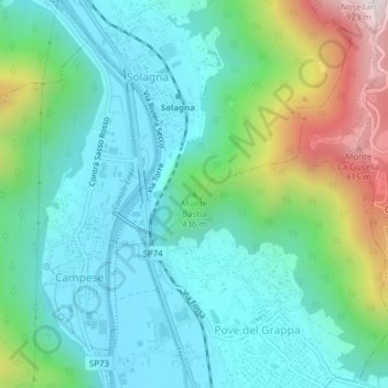
Name: Monte Bastia topographic map, elevation, terrain.
Location: Monte Bastia, Solagna, Vicenza, Veneto, 360612, Italia (45.80848 11.72278 45.80858 11.72288)
Average elevation: 1,020 ft
Minimum elevation: 364 ft
Maximum elevation: 2,930 ft
Other topographic maps
Click on a map to view its topography, its elevation and its terrain.
Ponte San Lorenzo
Ponte San Lorenzo, Solagna, Vicenza, Veneto, Italia
Average elevation: 3,917 ft