
Murs à Pêches topographic map
Interactive map
Click on the map to display elevation.
About this map
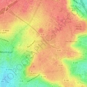
Name: Murs à Pêches topographic map, elevation, terrain.
Average elevation: 328 ft
Minimum elevation: 190 ft
Maximum elevation: 404 ft
Other topographic maps
Click on a map to view its topography, its elevation and its terrain.
Parc départemental Jean-Moulin - Les Guilands
France > Île-de-France > Montreuil
Parc départemental Jean-Moulin - Les Guilands, La Noue - Clos-Français, Montreuil, Bobigny, Seine-Saint-Denis, Île-de-France, France métropolitaine, 93100, France
Average elevation: 285 ft